
Scientists Watch Oceanic Crust Form in Real Time Now
Deep beneath waves that keep the Sun at bay, a 16-day drama unfolded that geologists had only imagined. In late April 2024 a stretch of the Southeast Indian Ridge suddenly tore open, magma surged, and new oceanic crust was born in plain — if remote — sight. What was once a slow-motion assumption about how Earth grows its skin now reads like an observed spectacle.
How the team trapped a rare event
Mid-ocean ridges are the planet’s underwater assembly lines. Across roughly 65,000 kilometers of seafloor, plate edges diverge and magma wells up to create new crust. Most of that work happens far below the surface, beyond direct human view. To stand any chance of catching one of the infrequent explosive episodes that forge new crust, researchers built patience into hardware.
In February 2024 the Observatory with Hydro-Acoustics and Geodesy near Amsterdam Island experiment — OHA-GEODAMS — was deployed at the Saint Paul-Amsterdam volcanic plateau on the Southeast Indian Ridge between Australia and Antarctica. The observatory combined five autonomous hydrophones, seafloor transponders for acoustic ranging, and geodetic sensors designed to measure movements of the seafloor with centimeter-to-meter precision.

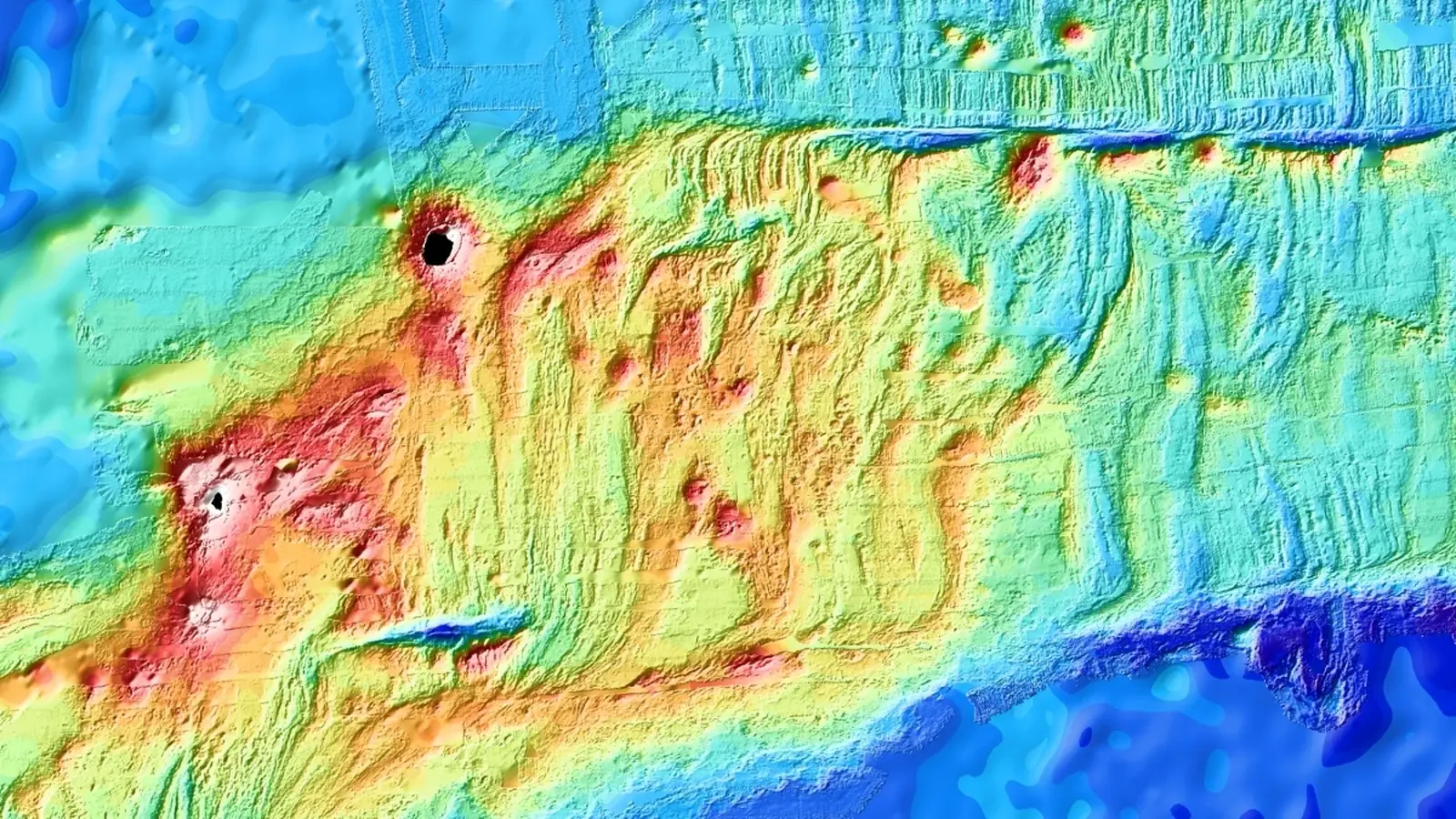
The tectonic setting of the observed seafloor spreading event.
For years the team had been waiting to measure small strains, the incremental stretching that builds stress over decades. What they recorded instead was off any expectation: meters of displacement, violent dike intrusions, earthquake swarms, and lava erupting on the seafloor all within days. As Jean-Yves Royer, the marine geophysicist leading the project, put it, "We did not dream of capturing such a massive event, and were hoping to at least measure the steady stretching of the ridge (maybe a few centimeters) that allows stresses to build up between events, like a loaded spring."
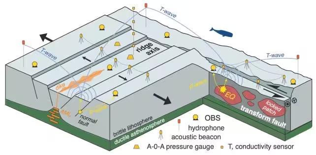
A schematic drawing of the complete observatory in early 2025.
What happened during the April episode
Beginning at the end of April 2024, the ridge axis failed and magma propagated laterally into the oceanic crust. Vast sheet-like intrusions called dikes ripped through the crust in under two hours, injecting an estimated 150 million cubic meters of magma. That volume is roughly equivalent to the output of a large continental volcanic episode translated to the seafloor environment.
As dikes advanced, they triggered earthquakes and activated faults bordering the ridge valley. The seafloor above the drained reservoir collapsed rapidly, with the floor of the central valley dropping by about 4.2 meters. Eventually the intrusions reached the seabed, producing lava eruptions and further subsidence as the magma reservoir emptied.
One surprising metric: at peak activity the ridge was opening at roughly 5 centimeters per minute. To contextualize, that is nearly half a million times faster than the long-term average spreading rate of about 6.3 centimeters per year. The horizontal displacements measured — between 2 and 4 meters — equate to decades of steady spreading condensed into hours. These so-called "quantum" events, discrete and powerful, appear to account for much of how the ocean floor truly grows.
Why this resolves a long-standing imbalance
For years a paradox bothered marine geophysicists. Plate motion measured over large scales implied a certain rate of seafloor creation, yet recorded earthquakes could not account for all the required motion. Where was the missing slip?
OHA-GEODAMS provides the answer: much of the movement occurs aseismically. That means the crust shifted without producing the strong seismic waves typical of big earthquakes. Faults slipped silently, dike intrusions accommodated motion, and seismic catalogs undercounted the full displacement. By directly measuring both the seismic and aseismic components, the study gives researchers ground truth to improve models of plate divergence and magma transport beneath ridges.


A watercolor drawing of one of the seafloor transponders by paper second author Jean-Arthur Olive.
The implications are practical, not just theoretical. Better accounting of aseismic slip refines hazard assessments for mid-ocean volcanic provinces, improves interpretations of seismic monitoring networks, and informs models of how magma chambers refill and drain. It also changes the timescale on which geoscientists must think: decades of slowly accumulating strain can be released in a single short-lived event that reshapes tens of kilometers of seafloor.
Expert Insight
Dr. Amina Castillo, a geophysicist and ocean observatory specialist at the Ocean Research Institute, offered this perspective: "This observation is a turning point. Until now our best guesses relied on indirect proxies. Having time-resolved, co-located geodetic and acoustic records allows us to separate the seismic from the silent components of plate motion. For future observatories, this demonstration means sparse arrays can be designed with targeted objectives and still capture fundamental processes."
The ability to watch these quantum events unfold will let scientists test hypotheses about magma chamber dynamics, fault interaction, and the mechanics of dike propagation. It also provides a template for deploying observatories in other mid-ocean ridge segments where episodic spreading may be the norm rather than the exception.
Technical and scientific context
Key technologies in OHA-GEODAMS combined long-duration hydrophones for acoustic event detection, transponder networks for precise distance measurement, and seafloor geodesy sensors to record vertical and horizontal displacement. Acoustic records capture the timing and propagation of dikes and eruptions across hundreds of kilometers, while geodetic fixes resolve motion with meter-level accuracy. Integrating both datasets transforms noise into a narrative of how crust forms.
One sentence takeaway: Seafloor spreading does not always proceed at a steady pace; it can happen in sudden, powerful pulses that account for decades of plate motion in hours.
Conclusion
Watching a piece of Earth's oceanic crust being born is not just a novelty. It changes how scientists measure and model the planet's tectonic behavior. The OHA-GEODAMS capture shows that the ocean floor grows through a mix of violent, measurable events and quieter, aseismic slips that have gone largely unnoticed by seismic networks. With instruments now proven in this harsh environment, the next step is wider deployment, longer records, and applying these lessons to other tectonic boundaries. If we want to understand the Earth's skin, sometimes we have to be in the right place at the right time — and build clever ways to listen when the planet finally speaks.

“My work centers on sustainability, energy, and environmental science — examining how innovation can lead to a greener future.”

Discussion
Leave a Comment
Comments (3)
Cool capture but feels a bit overhyped, media will spin it into endless drama. Still, clever sensors and solid proof, curious if it's repeatable.
Is the aseismic slip really that big? Sounds plausible but I want raw seafloor data not just summaries, anyone seen the recordings?
Wow, actual crust forming in days? chills. The opening speed stat is bonkers, 5 cm/min, what? If true this rewrites plate tectonics timing, need more data tho...